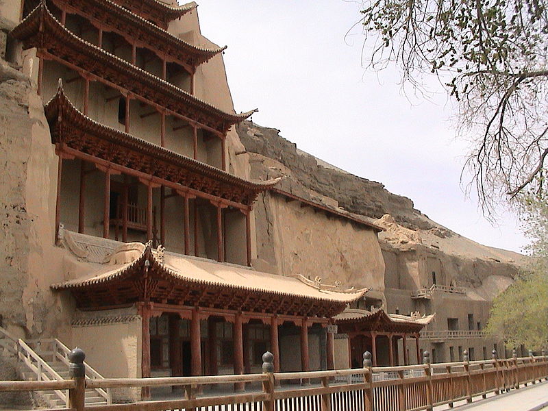
This summer I'm going to the Mogao Caves near the old Silk Road town of Dunhuang. I'm so excited!
Locked away in the heart of the Gobi desert, four days' camel ride from the nearest town, lies one of the least-known of China's many wonders, the 'Caves of the Thousand Buddhas' at Tun-Huang. Here, carved in irregular rows into the cliff face and filled with magnificent wall-painting and sculptures, are more than four hundred ancient rock temples and chapels. Tun-Huang, which means 'Blazing Beacon', was the last caravan halt in China proper for travellers setting out along the old Silk Road. Piligrims, merchants and soldiers about to leave China for the spiritual darkness and physical dangers of the Taklamakan desert prayed at Tun-Huang's shrines for deliverance from the goblins and other perils ahead.
I've been wanting to explore this area, and the even more forbidding Taklamakan Desert, ever since I read Peter Hopkirk's Foreign Devils on the Silk Road, which I quote above. Aurel Stein's travel memoir Ruins of Desert Cathay made me even more intrigued. But I never had an excuse until now! I'll be in Singapore this summer, but Chenchang Zhu has invited me to a conference on higher algebraic structures in Lanzhou, and we will take an excursion to Dunhuang, 1100 kilometers to the west.
I'm afraid I'm going to keep posting about this subject until August,
to relieve the twitchy excitement I'm feeling.
February 7, 2013
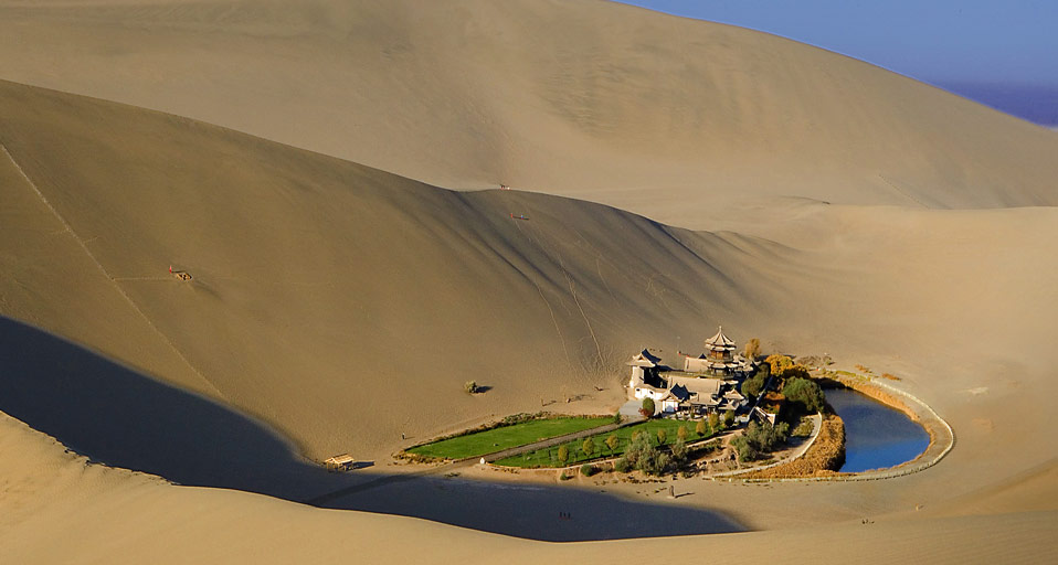
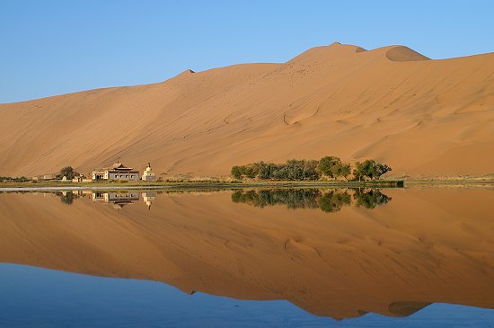
Just 6 kilometers south of Dunhuang you feel you're deep in the Gobi
Desert. But then you see an oasis called Crescent
Lake. You can get there on a camel or a four-wheel drive. I want
to go there! The lake was about 5 meters deep in 1960. By the early
1990s it had shrunk to just 1 meter deep. In 2006, the local
government started working to restore its depth.
February 8, 2013

Watch the seasons change! You can see the month at lower right. See the place north of India, north of Tibet, that never changes color? It's called the Taklamakan Desert. Sven Hedin, one of the first Europeans to explore it, called it the "worst and most dangerous desert in the world". It's a cold desert full of shifting sand dunes. Temperatures drop to -20 °C (-4 °F) in the winter, though it gets hot in the summer.
Dunhuang, the city I'm visiting in August, lies in the Gobi Desert, east of the Taklamakan. Travelers going west along the Silk Road would stop at Dunhuang before deciding to go north or south around the Taklamakan. Both these routes pass through ancient cities built on oases. I want to tell you more about this whole area. Not only is it the romantic Wild West of China, it's full of fascinating history, since the Silk Road was a meeting-ground of many ancient cultures.
This picture comes from a collection at the Digital Silk Road Project.
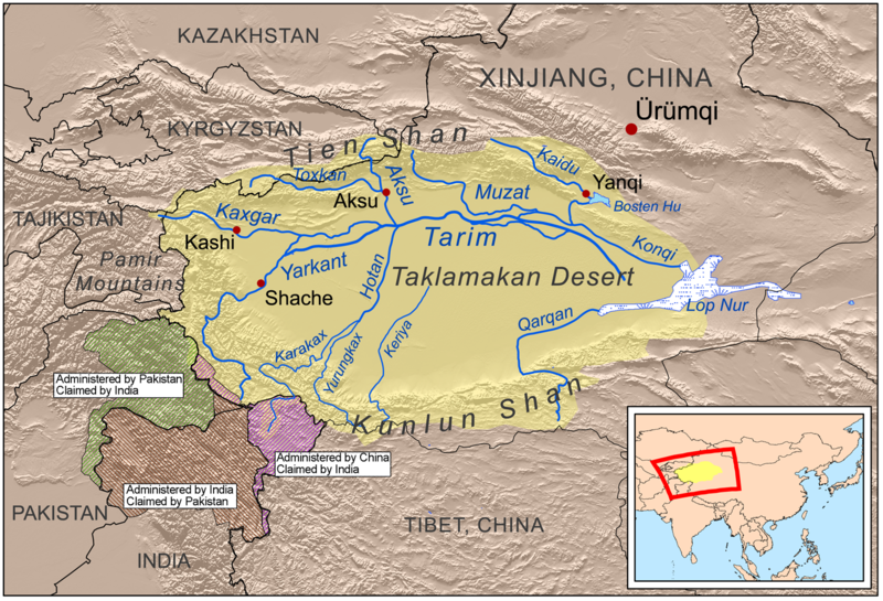
The Taklamakan Desert is almost surrounded by mountains: the Tien Shan range on the north, the Pamirs on the west, and the Kunlun mountains on the south. Water flows from these into the desert, into the Tarim River, and then to the mostly dried-up lake of Lop Nur. This let the explorer Sven Hedin travel by boat through the Taklamakan for eighty days back in 1899.
With a crew of five, he started on the Yarkand River and then took the Tarim almost to Lop Nur. Sometimes they would be carried by raging torrents; sometimes the river slowed and they would use a sail. For a while they got stuck in ice. At the end they discovered the ruins of Loulan, where they unearthed Chinese manuscripts from the Western Jin Dynasty (265-420)... and a wooden tablet with Kharosthi script on it!
Kharosthi was a language used in Afghanistan and Pakistan starting around the 3rd century BC, but later in Sogdiana, an empire centered around Samarkand. This language may have survived until the 7th century in some towns along the Silk Road.
Kharosthi is actually available as part of UNICODE, but my computer
doesn't display it, and yours probably doesn't either — so if
you're interested, go to the Wikipedia article.
February 9, 2013
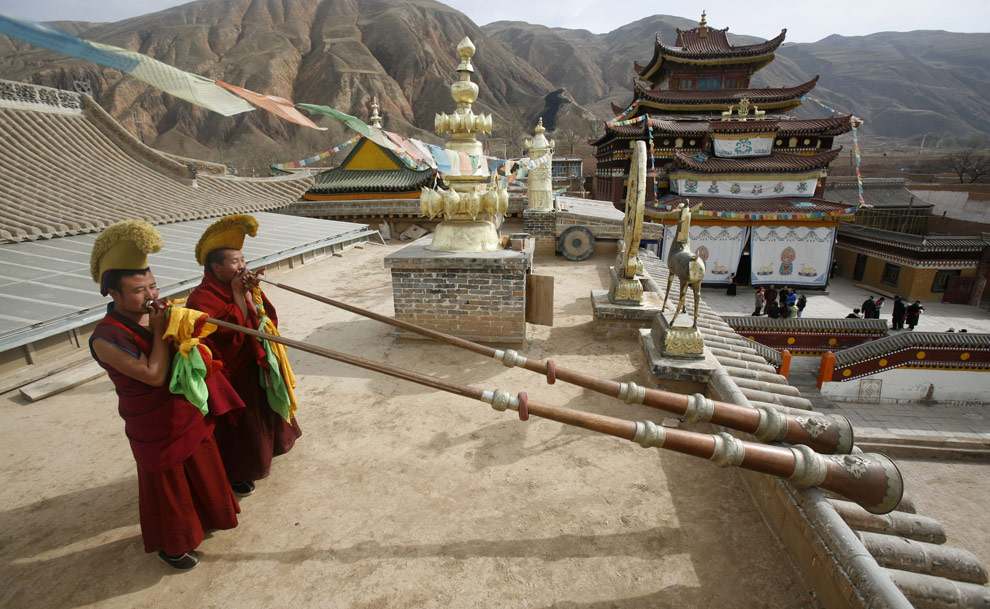
Lanzhou is a big city, but if you drive south it quickly becomes mountainous, and in 4 hours you can reach the Labrang Temple. It's still in Gansu province, but it's one of the main monasteries of the Yellow Hat school of Tibetan Buddhism.
Labrang was founded in 1709, and it sits at the meeting-place of four
Asian cultures: Tibetan, Mongolian, Han Chinese, and Hui, also called 'Muslim
Chinese'. It was one of the largest Buddhist monastic universities,
and a seat of Tibetan power until the early 1900s. It was repeatedly
attacked by the Ma clique, a group of Hui warlords in Northwestern
China who ruled the Chinese provinces of Qinghai, Gansu and Ningxia
from the 1910s until 1949. It was closed by the communists from 1958
to 1970. But it's active again, with about a thousand monks, and some
amazing annual festivals. I want to see this place!
February 9, 2013
Go 420 kilometers north of Lanzhou and you reach Badain Jaran, also called Badan Jilin, with the biggest sand dunes on Earth, near the edge of the otherwise rocky Gobi Desert. With immense optimism, a Chinese website calls this area a "resort":
Badan Jilin Desert Tourism Resort, with an area of 47 thousand square kilometers and an altitude of 1200-1700 meters, has an extremely dry climate and hot sunshine. The highest temperature in the burning summer time can reach 38°C-43°C. The surface ground even has higher temperature. The highest temperature of the desert can be up to 70°C-80°C. During the winter and spring time, the wind is very strong. On the eastern and south-western edges of the desert, the Gobi is boundless and infinite.Amazingly, there are lakes with fish here. Badan Jilin seems to be a Chinese form of the Mongolian name Badain Jaran, meaning Mysterious Lakes. And by one of these lakes there is a monastery, shown here.
No, it's not a resort! It cannot be reached except by camel or four-wheel drive, and in Nick Middleton's book Extremes Along the Silk Road his driver got stuck in dunes shortly before reaching it:
The driver kept trying. On a couple of occasions, we all jumped out to dig when our wheels buried themselves in the sand, each time agonizingly close to the summit of the ridge. After the second time, Bruno and I stayed out and trudged up to the summit to watch the vehicle, now slightly lighter, descend, circle, and try again.I don't think I'll be going here.It was late in the afternoon when we finally gave up, unloaded what we could carry and walked the rest of the way to the Alashan Miao monastery on the edge of the lake.
This photo was taken by kailas97. This guy has taken a lot of great
pictures of this rugged area! You can see them on Panoramio.
February 10, 2013
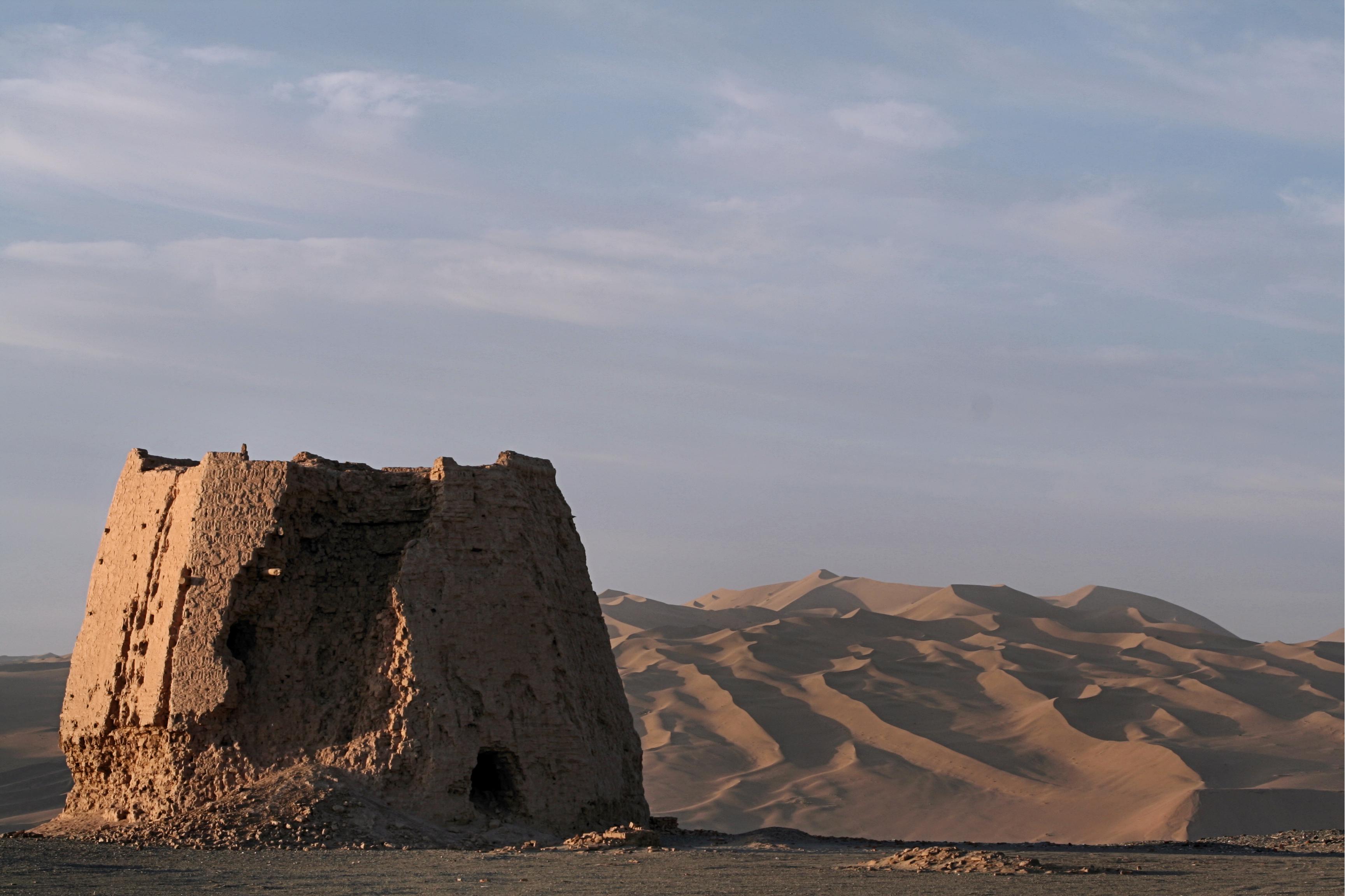
Here's an ancient Chinese watchtower outside the western part of Dunhuang, the Silk Road oasis town famous for its caves. In the background are the Mingsha sand dunes, which lie between Dunhuang and more distant mountains.
Dunhuang means 'Blazing Beacon', so perhaps we should imagine this tower lit up with flames. Daniel Waugh writes:
The physical geography of Dunhuang, its region, and the approaches to it help to explain why the town became so important militarily. The most logical route from the interior of China to the West moves through the "funnel" of the Gansu or Hexi Corridor, bounded on north and south by mountains. The mountains to the south are high enough to serve as barriers to invasion, and their glaciers fed the streams which made habitation in an otherwise dry region possible. To the north, the terrain is less well defended by nature; it was for this reason that, beginning in the last centuries BCE, the rulers of China began to create the "Great Wall," to defend against nomadic incursions. The Han emperors, especially beginning with Wu-Ti (141-87 BCE) extended the wall and its network of watchtowers along the Hexi corridor, through the "bottleneck" at Jiayu Guan (later to be the western boundary of China under the Ming) along both sides of the broadening valley past Anxi and well beyond Dunhuang. The British explorer Aurel Stein made the exciting discovery that the Han "limes" extended all the way to Lop Nor, the salt lake at the edge of the Taklamakan Desert.Here "limes" is an allusion to the walls marking the limit of the Roman empire.
While it was possible for invaders to break through the defenses to the east of Dunhuang, the fortifications there in a real sense were the gateway to inner China. Even at the greatest extent of Chinese power in Inner Asia in the period up to the end of the first millenium CE, Chinese control beyond Dunhuang was exercised largely through vassal states. Written records indicate that Chinese travelers to the West clearly sensed they had stepped into another world at the moment they passed through the "Jade Gate." To go beyond was to leave behind the comforts of home and to enter culturally alien lands. Except for the garrisons manning the watch towers and small forts, Chinese armies almost inevitably retreated behind the defenses, often in disarray from their inability to provision themselves adequately on long stages through the desert.
I got this information from Daniel
Waugh's Dunhuang website, and the photo from Wikipedia.
February 11, 2013
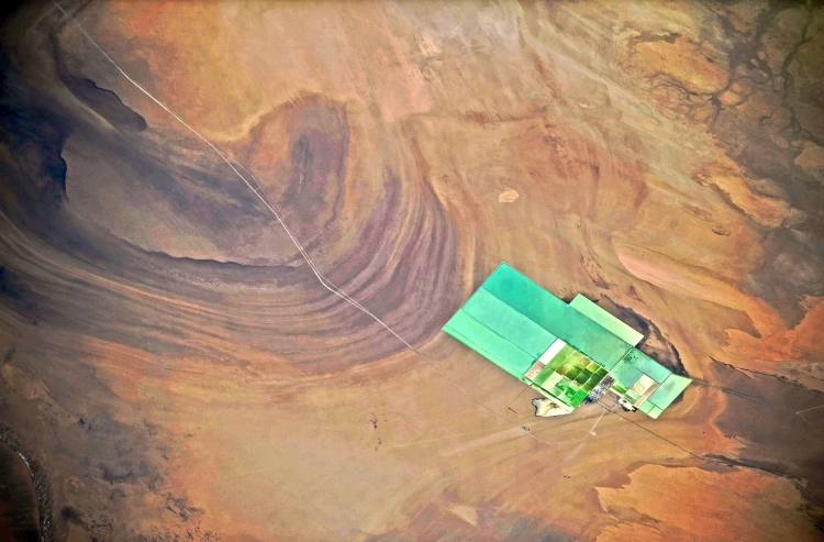
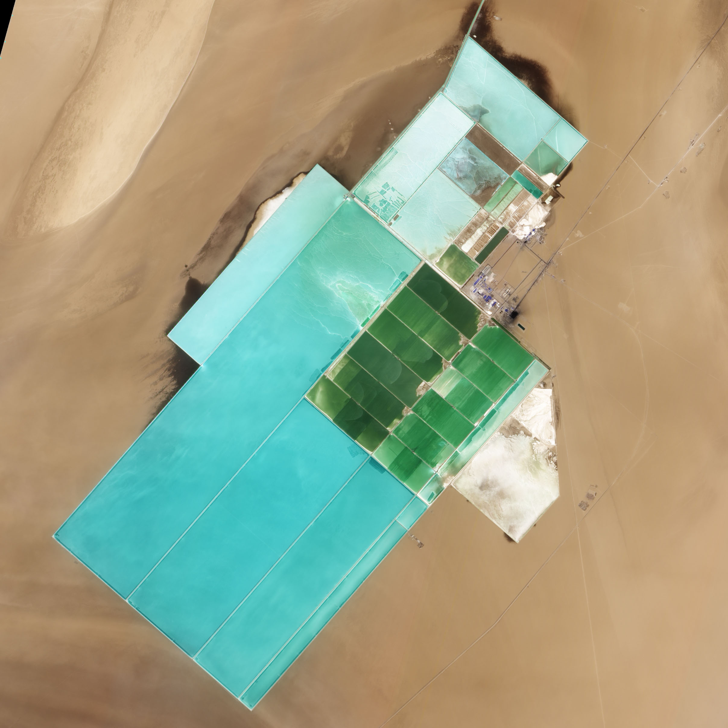
This thing at the eastern edge of the Taklamakan Desert is big. It's about 6 kilometers across and 20 long. You can see it on Google Maps here: Lop Nur. What is it? Could it be a
...training ground for human-fish hybrids, in preparation for colonization of the Pacific floor?That's what one blogger jokingly suggests, but NASA's website gives the real answer:
Located in China's resource-rich but moisture-poor Xinjiang autonomous region, Lop Nur is an uninviting location for any kind of agriculture. It sits at the eastern end of the Taklimakan Desert, where marching sand dunes can reach heights of 200 meters (650 feet), and dust storms rage across the landscape.Yet for all it lacks in agricultural appeal, Lop Nur offers something valuable to farmers the world over: potash. This potassium salt provides a major nutrient required for plant growth, making it a key ingredient in fertilizer.
The discovery of potash at Lop Nur in the mid-1990s turned the area into a large-scale mining operation. The Advanced Land Imager (ALI) on NASA.s Earth Observing-1 (EO-1) satellite captured this natural-color image of Lop Nur on May 17, 2011. The rectangular shapes in this image show the bright colors characteristic of solar evaporation ponds. Around the evaporation ponds are the earth tones typical of sandy desert.
During the early and middle Pleistocene epoch, this area held a large brackish lake. Uplift of the northern part of the lake in the late Pleistocene created hollows that became receptacles for potash deposition. The main potash deposits found at Lop Nur today are brine potash, and this site is the second-largest source of potash in China.
Lop Nur slowly dried up in the Holocene. The area now receives average annual precipitation of just 31.2 millimeters (1.2 inches), and experiences annual evaporation of 2,901 millimeters (114 inches), according to a study published in 2008. The study found, however, that this area has experienced seven major climate changes since the end of the Pleistocene, including climatic conditions far more favorable to farming and settlement than today.
Examination of plant and mollusk remains at the lake, as well as studies of sediments, indicate that the Lop Nur region experienced a severe drought about 3,000 years ago, followed by wetter conditions. Between 1,250 and 400 years ago, Lop Nur likely experienced the conditions most favorable to farming and settlement, and red willow trees grew in the area. Pottery dating from the Tang and Song dynasties further testifies to welcoming conditions at the lake centuries ago.
Starting around 400 years ago, however, a more arid climate took hold, completely drying out Lop Nur. Today, by providing potash, the desiccated lake still supports agriculture, but it does so for farming efforts further afield.
The photo mentioned above is not the one you see here — it's on NASA's webpage and it looks like this:
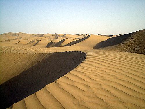
While the edge of the Taklamakan Desert is a gravel desert with scattered oases, its heart consists of shifting sand dunes. In general, these dunes are between 20 and 100 meters high, and they are crescent-shaped. They're called barchan, and they slowly move along with the wind, with a steep downwind face and a less steep upwind face.
This photo was taken by zhou1 near the eastern end of the Taklamakan, and you can see it together with others on Panoramio.
The nearest town seems to be Qiemo, also known as
Charchan or Qarqan. This town has a history dating back to the Bronze
Age: some 2,400-year-old mummies were found less than five kilometers
southwest of the city center. During the Former Han Dynasty (123 BC
to AD 23) it was described as having "230 households, 1610 individuals
with 320 persons able to bear arms..." with grapes and various types
of fruit. The climate was wetter then!
February 16, 2013
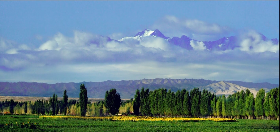
Tian Shan means 'heavenly mountains', and here they seem to be floating in the clouds! This was taken north of Dabancheng, a small city at the northeast edge of the Taklamakan Desert. While this desert is fiercely dry, its fringes gather rain and runoff from the surrounding mountains, and here the land looks downright delightful.
The Tian Shan range forms the northern border of the Taklamakan Desert. This range was formed along with the Himalayas by the collision of the Indian and Eurasian plates, starting about 60 million years ago near the beginning of the Cenozoic. It's one of the longest mountain ranges in Central Asia - 2800 kilometers long, going east from Tashkent in Uzbekistan all the way to where this picture was taken!
Dabancheng is pretty obscure, but it's near a much bigger city, Urumqi. This was an important Silk Road stop in the Tang Dynasty. It's also farther from any ocean than any other city in the world: 2500 kilometers to salt water! This area is truly the 'Wild West' of China.
This photo was taken by ssSUH, and you can see it together with others on Panoramio.

The Silk Road town of Turpan is near the hottest, driest part of China — but it's famous for its grapes. How do they get water? Starting around 100 BC, people have dug wells and linked them with underground canals to collect runoff from the nearby Tian Shan mountains and carry it to their farms!
These canals take advantage of the steep land: while the mountains are quite high, the nearby Turpan Depression is the third lowest place on the Earth, 145 meters below sea level. Having canals underground helps reduce evaporation. They provide water year-round. They clearly work: there are over 1100 wells, and the canals have a total length of over 5000 kilometers!
Underground canal systems of this sort are common in the Middle East. Such a thing is often called a qanat — an Arabic word — but in Turpan they speak of the karez system, after a closely related Persian word, which has found its way into the local Uyghur language.
Sylvia Volk has a great page describing how qanats are built:
First, you need a man with money to invest. Qanats are a good, sound investment: a well-made qanat can be used by many families for many, many years. Two or three good qanats will supply all the irrigation water for a small village. And the man who builds the qanat owns the water that runs through it; the family who owns a qanat will be collecting revenue for several generations to come.Next, you need a water-finding expert. The process by which they locate a water-source is apparently a jealously-guarded secret. But what is needed is a good well, about three hundred feet deep, with enough water that the bottom will accumulate a depth of two meters overnight. It has to be uphill of the area to be irrigated; that's very important. If it's not uphill, it's useless.
Surveyors follow the water-finding expert, and dig their well. This well is called 'the mother well'. The surveyors measure its depth with a rope. They calculate where the qanat will come out . . . and this must be on lower ground (naturally!) feasible for farming. (Most of the Asian desert is feasible for farming - just as long as you can get water to it.)
But this is how the surveyors find the spot where water will flow out: they set a pole upright, some distance downhill from the mother well. And stretch a string taut - from the well, to the pole. The string has to be leveled, and this they do by dripping water on it, and adjusting the tilt of the string until this water runs both ways (!!). Then they note the spot where this string meets the pole, and measure the height of the pole on the rope which measures the mother well's depth. They tie off a knot on the rope to mark it. Then they set out another pole downhill, mark the height, tie another knot, etc . . . and when the whole length of the string is knotted off, they have found the level at which the water must emerge. Theoretically. It seems like a hit-or-miss prospect to anyone raised with Western engineering; but this is stone-age technology, done with stone-age tools. And it does work: the proof is in the qanats.
The last task given to these surveyors is to dig shafts every three hundred yards along the course of the qanat, referring to the knotted string to dig to the correct depth.
Next, qanat experts called muqannis are called in. Wise men that they are, they start a little downhill from the emergence level indicated by the surveyors. The surveyors' shafts guide them, but they dig their own shafts every fifty feet or so, to remove material and for ventilation. Then they dig the qanat's channel, starting at the bottom and burrowing until they come to the top, and this is the channel down which the water will run. This is the business part of the qanat, and the muqannis dig the whole thing underground. It's a tunnel linking all these shafts together.
The channel is kept reasonably straight by placing two lamps in it, behind the diggers and several yards apart from each other. Then, the diggers can glance back over their shoulders as they work; if they see the two flames superimposed on each other, they know the way is straight. Nevertheless, there are usually sharp kinks in the channel just below each well, marking errors in the direction taken by the muqannis. Remember, these diggers start at the bottom and work uphill toward the mother well. When the muqannis reach water-bearing strata, the seepage runs away down the channel behind them. <> Just before the channel breaks through to it, someone has to empty the mother well; otherwise, the diggers won't be happy men. (You could lose a lot of muqannis that way.) However, once the channel breaks through, the muqannis are finished. If need be, they brace the qanat walls with oval bricks. They leave the original shafts open, so that they can climb down into the qanats and clean them if necessary; for muqannis also hire themselves out as qanat maintenance men.
And there you have it: a working qanat. A great boon to the community. It will be honored with a name of its own, for qanats are always given names. On the surface, it will be visible from an airplane: it will be a line of perfectly round green spots running across barren ground, and these green spots are lush grass growing around each ventilation shaft. The shafts themselves are usually capped with wooden covers, but obviously the moisture escapes. The channels of the qanat will be about four feet wide, and muqannis will walk them regularly, cleaning them as sewers are cleaned - and ducking, for bats with eight-inch wingspans live in the qanat tunnels and fly in and out at every exit. At the qanat's outlet, canals will run in every direction, carrying the water to fields and gardens and houses. A single qanat in Iran usually run two miles or more, and irrigates an area two miles square.
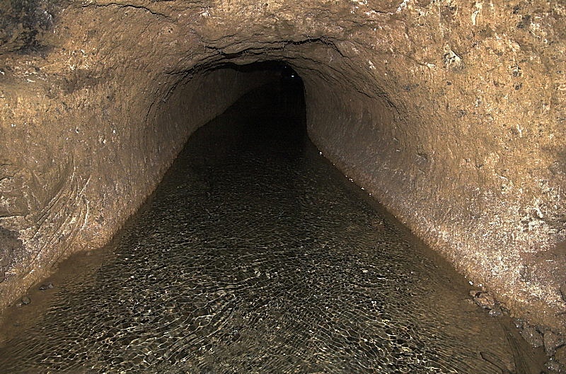
Here's an underground canal, or 'karez', in the old Silk Road town of Turpan. It looks spooky, but it must be great to see water in this town at the edge of the Taklamakan Desert! It only rains 1.6 centimeters per year on average. And the climate is harsh. The summers are long and very hot, the winters are short but very cold. The temperature easily drops to -12 °C (10 °F) in January, and shoots up to 40 °C (104 °F) in July. But thanks to the karez system, the hot dry summers let the farmers around Turpan grow a lot of high quality fruit. The town is famous for its very sweet grapes and melons.
This picture was taken by Vinh Binh.
© 2013 John Baez
baez@math.removethis.ucr.andthis.edu