Did you know that in 1532 the Sultan of Yarkand — an important city in Central Asia, back then — tried to march all the way to Tibet and take the city of Lhasa, because he believed it was the qibla, the direction of prayer, for all Buddhists? His horses all died of altitude sickness before he got there. This is just one of many things I learned from Buddhism and Islam on the Silk Road, by Johan Elverskog. Having grown up learning lots of European history, it's great to see the world from a different perspective, in which Central Asia is the center. It's so cool! For example, here's a bit about the Qara Khitai Khanate, or Western Liao — an important empire from 1120 to 1350:
On account of their Sino-nomadic legitimization the Qara Khitai state therefore functioned as a perfect buffer between the Muslim world and the Tantric Bloc. In large measure the Muslim and Buddhist worlds would therefore remain separate during the Western Liao. The coming of the Mongols, however, was to change this dynamic completely. Yet before turning to the impact of the Mongol conquest it is important to leave the Muslim world and outline the developments in the Buddhist world. Indeed, to avoid the common mistake of ignoring the interconnectedness of Eurasian history we need to keep in mind that developments in the Buddhist world were intimately related to events unfolding in Muslim Central Asia. In fact, the very creation of the Tantric Bloc, with Tibet as its spiritual core, was very much related to the course of events described above.The 'Tantric Bloc' is Elverskog's name for a loose collection of states influenced by Tantric Buddhism, eventually running from Tibet through Mongolia all the way to Japan.The most important element in this regard was clearly the revival of Buddhism in Tibet. After the Tibetan Empire collapsed in the ninth century so too had Buddhism on the Tibetan plateau. Yet on account of the Muslim advance into the Buddhist frontier zone Buddhist masters from places like Kashmir and Khotan started to seek refuge in the Guge kingdom of western Tibet. And as news spread of this Buddhist revival in Tibet ever more Buddhist masters from South Asia made their way across the Himalayas.
[...]
One one level the diaspora of these Khotanese, Kashmiri and Indian Buddhists into Tibet could have ended as with the Nestorian Christians in Central Asia: as an historical oddity of little concern to anyone. Yet that was not to be the case. As we all know Tibet and its Tantric Buddhism continues to exert a powerful influence on the world stage. Why and how this happened is far beyond the scope of this study; nonetheless, one thing is clear: the Indian masters and their Tibetan disciples turned the obtuse antinomianism of Tantric Buddhism into gold.
[...]
The reasons for this are many, though one important factor in this development was, oddly enough, the Muslim invasion of India. It was this event that set in motion the brain drain of tantric masters that ushered in both the withering of Buddhism in India and the simultaneous growth of the Dharma in Tibet.
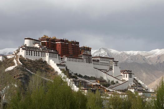
This photo of the Potala Palace in Lhasa is from Around the World in 80 Clicks, a travel photo website.

I saw this picture by George Steinmetz here:
The Tarim Desert Highway across the Taklamakan desert, in China, links the cities of Luntai and Minfeng on the northern and southern edges of the Tarim basin. The total length of the highway is 552 km, of which approximately 446 km is built across uninhabited areas covered by shifting sand dunes, 20 metes tall, that frequently bury the highway.To prevent the highway from getting buried by the encroaching sand dunes, rows of vegetation were planted on both sides of the road to anchor the sand with their roots. A massive irrigation system was constructed that pump water from underground reservoirs to sustain the artificial ecosystem. Hundreds of workers were employed, housed every four kilometers along the road who tend to the short, small-leaved rose willows, sacsaoul and buckthorn and make sure they do not die. The water comes from wells, bored 100 meters deep into an aquifer which sits under the desert, which in turn is fed by the rivers that flow down from the surrounding mountains. Despite the high saline content in the water, the green belt continues to thrive.
For five years the government experimented with various plants that could survive desert conditions. In 1999, a pilot project of sand protection afforestation belt along a 6.3-kilometer section of the highway was completed. In 2001, the project was expanded until a 30.8-km stretch along the highway was afforested. The project was finally approved by the state in 2003. Today, nearly four-fifth of the highway is flanked by 72 to 78 meter-wide tree belt, covering a total area of more than 3,000 hectares.
The Tarim Desert Highway has great economic significance, which is why such expensive and elaborate measures had to be adopted just to keep the highway usable. The highway was built in 1995 to service an essential north-south oil pipeline, that lies underneath the Taklamakan desert. Beneath the shifting sands contains the largest oil-gas field in China. The highway not only allows direct access to resources that lie underneath the Tarim Basin, but also allows transport of goods and resources from the Lunnan Oilfield to the south of the country rather than take a detour around the desert that would encompass hundreds of kilometers. Because the region is entirely uninhabited, a gas station and a few restaurants were built at the halfway point along the desert highway to service travellers.

Even a camel can get tired crossing the Taklamakan Desert! This photo was taken by Richard Desomme in a flat barren area east of the Yurungkax River and west of the Keriya River. There's a story to be told here, but I don't know it. The precise location is 37° 51' 27.03" N, 81° 13' 58.48" E.

This is the entrance of a man-made underground canal in the city of Turpan, China, northeast of the Taklamakan Desert.
Turpan lies in the second deepest geographical depression in the world, with over 4,000 square kilometers of land below sea level! It has short cold winters but it gets really hot in the summer, with average high temperatures over 32 0C (96 0F) from May to September, and sand storms. Luckily, melt water flows down from nearby mountains. This makes their karez system of wells and underground canals really helpful! They have over 1100 wells, and over 5000 kilometers of underground channels.
The inhabitants of Turpan started building this irrigation system during the Han dynasty (206 BCE-24 AD), when this city was part of China. When that dynasty collapsed, Turpan became part of an independent kingdom whose capital was the nearby city of Jiaohe (now abandoned). Turpan became important as a stop on the Silk Road, frequented by Chinese and Sogdian traders... and after various twists and turns it was recaptured by the Chinese during the Tang dynasty, in 640 AD.
All this is on my mind because I'm planning a trip in August. Lisa and I might fly out to this area on August 8, meet the mathematician Weiwei Pan, and make our way to Dunhuang by August 11. It seems easier to fly to Urumqi than Turpan, but Turpan looks more interesting — though hotter, and a 2-hour train ride away. I have a limited amount of time — should I go there? I actually prefer staying places and getting to know them, so we may just go to Dunhuang and look around there. Then Lisa has to leave, and Weiwei and I will go to a math conference in Lanzhou. It looks close on a world map, but it's 1000 kilometers to the east! After the conference we may poke around Qinghai, a mountainous province just a bit west of Lanzhou.
© 2013 John Baez
baez@math.removethis.ucr.andthis.edu