Return to Contents Page 
  Return to Highway Page 
This page contains my personal report on highway conditions along the Transpeninsular Highway (Mexico Route 1). Look in the Travelers' Reports Page for information provided by other Baja California travelers. I generally drive three to four round trips on the highway each year. The last trip I made was from La Paz to Southern California in November of 1999.

Fred Metcalf

 Page Contents
 Highway Notes   
 Flower Photos   
 Special Notes   
 Flags           
 Checkpoints     
Baja California Information Pages

Recent Road Conditions
Transpeninsular Highway

    Highway Notes
Next
 Back to Page Contents


In November '99, the road was in very good condition down to La Paz. There were only a few potholes in the northern state (south of Cataviña and south of the LA Bay Junction), and none in the southern state.

The paving south of Maneadero has progressed to Km 166, and come to a halt. There was no evidence of the highway reconstruction extending further south at this time.

Just southeast of Santa Rita (between Constitución and La Paz) the large vado is getting a bridge. The construction process will be continuing for some time. There is a short paved detour which is in good condition (a situation which can change in the event of heavy rain).

The construction which has been making the entrance to La Paz difficult for over a year, is now finished! At least as far as the intersection with Colosio and Abasolo. When you reach the airport turnoff (coming from the north), you'll find a wide four-lane concrete highway with a speed limit of 110KPH. The speed limit quickly drops, however, as you approach a long string of new stoplights on the Abasolo route into La Paz (left at the dove/whale monument). These stoplights are not coordinated, nor are there vehicle detection sensors buried in the street - the lights have a fixed cycle which just repeats - day and night! This can lead to frustrating waits, something many locals have learned to cope with - by just charging on through if no traffic is crossing.

Along Abasolo, from Colosio to Colima (CCC supermarket), the road is torn up and very rough. For large vehicles, the recommended route would continue to be Las Garzas/Olachea (right at the dove/whale monument) and a left on Jalisco.

Side trips (November '99):

Mission San Javier
Burros
Cow
Click photo for
a larger image
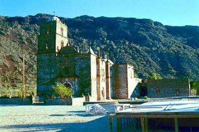
San Javier. On the trip north we traveled up to San Javier to see the mission as it was being prepared for the 300th year anniversary (I believe the celebration is scheduled for December 5). There was lots of activity going on as stands were being constructed, the interior was being cleaned and painted, and sod had been planted in the courtyard in front. (Yes, you read that correctly! Squares of sod had been carefully placed to fill the corners of the courtyard. I can't imagine where it might have come from within 600 miles.)

The road from Highway 1 to San Javier was in generally good condition. The only obstacles were four legged ones, and these were in abundance.

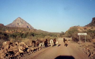
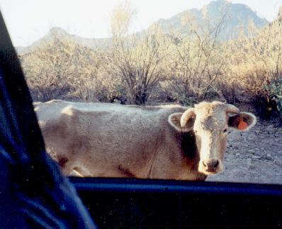
L.A. Bay. The road to LA Bay was in generally poor condition (no surprise). The good sections were long enough to sucker me into too much speed for the pot holed sections - lots of dancing the pothole polka! Following a recent recommendation in a Travelers' Report, we stayed at Larry and Raquel's Motel and enjoyed the place very much. A great fish dinner served on the second floor porch.
El Mármol. The road in to the old onyx mine is in good condition. The trip could be made in a sedan with just a bit of care.
Punta Baja. The road from El Rosario out to Punta Baja was smooth - it appeared to have been recently graded. The eastern crossing of the stream bed was dry due to a culvert which I don't recall from my last trip out there. The western crossing of the stream bed should be attempted only with four-wheel drive vehicles.
Baja 1000 Checkin Gary Dubin
Baja 1000 Checkin Baja 1000 Checkin
Click photo for a larger image
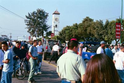
Ensenada. While it's hard to think of Ensenada as a side trip, on my trip south I was passing through town thinking mostly of breakfast. Suddenly I came upon a large crowd and a large inflatable Tecate can. Well, breakfast came first, but then I returned to the scene of the commotion and found . . . check in time for the Baja 1000 off-road race! 
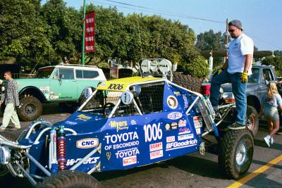
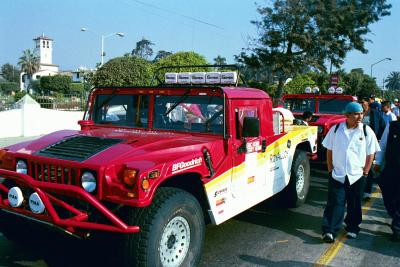
I've added a few photos I took wandering around the lineup of vehicles. The first is interesting in that it shows the multi-faceted nature of modern Ensenada - a cruise ship is docked in the background, and race fans are milling about the 
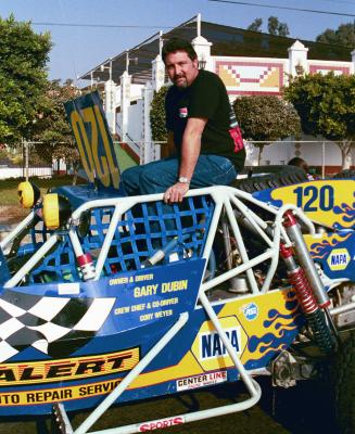
lineup. The second shows Gary Dubin posing with his car, and the remaining two shots show some unidentified vehicles.

Warning Topes (Speed Bumps): The topes which have been a hazard in Maneadero for a number of years are now completely gone! However, to illustrate the "Universal Law of Topes," which says that the number of topes in the Universe can only increase, the topes of Maneadero have headed south to warmer climates - and multiplied.

Note (November '99): The topes which have been a fixture in Ensenada since sometime before I first visited there in 1966, have been removed, except for one on each side of the street. This is the area next to the boatyard as you enter the city along the waterfront.

Topes are now to be found on the highway in:

  • Santo Tomás (2)
  • Vizcaino (5)
  • San Ignacio (3)
  • Santa Rosalia (3 topes north of "Y" intersection)
  • Mulegé (3)

Note that some of these speed bumps have no warning markings! There may be a sign announcing an area of topes, but nothing marking the individual bumps, except some faded paint on the street or the bump. The count of topes given reflects only those topes found on the main highway - there are often more in the towns.

Warning Tourist Cards: On my trip south in August, an immigration official was present at the checkpoint south of Maneadero. While it appeared that this may become a permanent screening point to enforce the new Tourist Card procedures, there was no official there in November.

Construction Delays: When you encounter road work going on, you can expect some delays. Two types of "detours" are found: single-lane traffic through the construction (either a flagman or a guiding vehicle is used); or dual-lane traffic around the construction, using a dirt road at the side (these can be very soft and dusty).

In November, there were only one detour of note. In south Ensenada a section of the southbound highway is being reconstructed. This involves a detour of about a mile on a slightly bumpy dirt road.

Note: New paving may lack any center striping - such areas should not be driven at night.

Pemex Stations:

Construction on the new Pemex station at the Eagle monument seems to have come to a halt.

Fuel: In November of '99 I encountered no fuel shortages.

In June of '98, I did encounter one fuel shortage on the trip south. The station at Vizcaino was out of diesel fuel. This forced me into continuing on to the station at Santa Rosalia, a station I usually try to avoid because of their reputation as "thieves." I could have made it to Mulegé, but wanted to play it safe.

I pulled into the Santa Rosalia station with two ideas in mind: either get a small amount of fuel so I could reach Mulegé with a good reserve, or fill up and watch the attendant like a hawk. I elected for the second course of action (a mistake in retrospect).

I made certain the pump was zeroed before pumping began and then watched the operation closely . . . until a kid washing the windows distracted me. When I returned to the pumping process the attendant was moving the hose from the front tank to the rear tank (my truck has dual tanks), and seemed to have zeroed the pump again, except it read 80 pesos. I made him stop until we agreed he'd pumped 80 pesos worth of fuel into the front tank.

He then filled the rear tank and went to "top off" the front tank (not zeroing the pump in this case). The bill for the fueling was 306 pesos, very close to what I had paid at my previous stop in El Rosario (300 pesos) with about the same amount of remaining fuel. I felt like it had all worked well, and that I'd not been cheated.

After leaving the station and getting back on the highway I switched the tank selection from the rear (now quite full) to the front. I'd been nailed again!!! The front tank showed less than three-quarters full. Since the price of fuel was the same, the needed amount of fuel about the same, and the total cost about the same, my only conclusion is that they've set the pump(s) at Santa Rosalia to read about 15% high.

November 3, 1998. Dave Stogner has provided an explanation of the particular scam I was subjected to. The matter was not an inaccuracy of the pumps, but a clever use of the "emergency stop" button.

Here is Dave's explanation:

The "emergency stop" button is pushed while you're not looking. This resets the register to some even amount ($90, $80, etc.), and then the attendent explains that you owe that amount and it will be added to the amount from the remaining fillup. He must then reset the pump by holding the button down, and at this point you will see the register counting down by 10's to zero. This is probably most frequently used when there are two tanks being filled.

Message: I'll continue to strongly recommend that you (and, especially, I) avoid the Santa Rosalia Pemex station.


    Flower Photos
Prev
Next
 Back to Page Contents


The flower photos have been moved to a separate section on the Photos Page, and added to the large Slide Show.


    Special Notes
Prev
Next
 Back to Page Contents


U.S. Vehicle Inspection: In May '99 I traveled to La Paz from the Tijuana airport. While walking across the border I noted that the inspection on the U.S. side had cars backed up about 1/4 mile. This inspection for stolen vehicles has been an occasional one in the past, but appears to have been institutionalized (there are concrete barriers separating the lanes).

In August, '99 we experienced about a ten minute wait at this inspection. In November the area was not manned at about 7 AM.

Spraying: Beginning in 1998 there is a new program of spraying the undersides of vehicles at the Guerrero Negro Agricultural Inspection Station. This is sponsored by the government of the Municipio de Mulegé in the southern state, so affects those vehicles headed south. There is a charge for this: 10 pesos for an automobile and 20 pesos for an "RV". In June, my two-axle pickup with a camper was judged to be an RV. However, in August I queried "¿10 pesos?," and was given a yes.

New Gasoline: There is a new gasoline being sold. It has the name of "Premium," and is priced well above the "Magna Sin" (a Premium name deserves a premium price!). I know nothing of its intrinsic qualities. The color on all of the pumps was uniform, a fact which made me double-check that I was, in fact, getting the diesel my truck requires. You have to differentiate between the pumps by labels (and prices) - a fact which, in the long-run, may produce problems as the labels wear off.

L.A. Bay: The Pemex station at the junction with the L.A. Bay road was closed permanently in January '96.

Time Change: In the spring of '96, the southern state of Baja California Sur (and, in fact, all of Mexico) began observing Daylight Savings Time for the first time. The days for the time shifts coincide with those observed in the U.S..


    Flags
Prev
Next
 Back to Page Contents


This is not a road comment, but more of a report on a brief amusement which I watched on my September '97 trip.

Sometimes in Southern California you see immense American flags being flown, typically at automobile dealerships, especially those selling foreign-made vehicles. Apparently, a competition to see who can wave the largest flag. Well, in Mexico, it seems that the Army is out to win the flag-waving contest in that country.

As I was passing the Army base on the south side of Ensenada, I noticed an unusually large Mexican flag flying. As I got closer, I realized that this flag was, perhaps, the largest I'd ever seen! It was standing out smartly in a fresh breeze off the bay. Impressive!

The next day, as I neared the state border and the Eagle Monument just north of Guerrero Negro, I again noticed something flying in the distance. It appeared that two flags were flying at the Army base newly-sited at the monument - probably one flag flying from each of the Eagle's wings, I thought. When within a mile or so, it became apparent that this was one flag - I'd been seeing the green and red sections, while the white section blended into the sky background.

This flag was also standing out smartly, in a more than fresh breeze coming off the Pacific. A small dust storm had sprung up around the Army encampment. Just as I reached the circular road around the monument, the giant flag began to lower. Concern over the safety of the flagpole, I'm sure.

I quickly began to wonder just how they'd get this giant piece of cloth taken in. I stopped in the road outside the entrance to watch. It took two soldiers to lower the flag, and ten others to attempt taking it in!

I find it difficult to judge the size of these new Army-issue Mexican flags. Perhaps 80 feet by 30 feet? At that size, we're talking about 2400 square feet of "sail" to take in! And probably a rather heavy weight of cloth to boot.

Flag

Note: In June '98 a new, heavy-duty flagpole was in place. The flag again stood out in a fresh breeze, but there seemed to be no concern for the flagpole. Here is a photo (click on the image to bring up a larger version):


    Checkpoints
Prev
Next
 Back to Page Contents


The checkpoints which appeared along the highway during 1996 seem to have become institutionalized. These checkpoints are a result of the U.S. "War on Drugs" which was started in the 1980's and (in my opinion) quickly showed itself to be a failure. However, for reasons political the "war" goes on - largely in some else's back yard!

The checkpoints have been established to "certify" Mexico as a "good participant" on the side of the U.S. in this war. If Mexico were not so certified they would lose a preferred status for U.S. loans.

Mexico has been pushed into a position I'm sure they'd rather not be in. However, they are in a difficult financial situation and need assistance from the U.S. - and the price they have to pay is that of attempting to halt the flow of illegal drugs passing through their country.

Almost all of the checkpoints ("Puestos de Control") at which a search for arms and drugs ("armas y drogas") may take place are manned by Army personnel. The PJF or PGR still maintains a partial presence at several checkpoints. In August there was only one checkpoint fully run by the PGR.

Be aware that checkpoints manned by soldiers may appear frightening. The soldiers are mostly young men carrying automatic weapons, and speaking very little English. However, my own experiences have been generally good. The only real problem has been my own aggravation at having my private space searched by someone else, or having to clean boot marks off the floor of my camper.

The Army has established a very permanent encampment surrounding the Eagle Monument at the state border. There may also be soldiers stationed at the Agricultural Inspection Stations.

Caution: A warning has been passed on by several travelers who experienced instances of soldiers going through purses and wallets while the driver and/or passenger appeared not to be watching. It is suggested that you either lock your vehicle if you go with a soldier to the back of the vehicle, or make certain a passenger is watching any valuables left inside the vehicle.

Checkpoints - Traveling South
(November 1999)
Location Personnel Action
Maneadero PGR & Army Questioned
No immigration personnel present
San Ignacio Army Searched
Loreto Army Searched
La Paz Agricultural
Inspection Station
Army Searched
No customs personnel present


Checkpoints - Traveling North
(November 1999)
Location Personnel Action
La Paz Agricultural
Inspection Station
ArmySearched
San IgnacioArmySearched
Eagle MonumentArmySearched
S. of LA Bay JunctionArmySearched
ManeaderoArmy & PGRQuestioned
No immigration personnel present

Review (1998): After two years of these checkpoints, the process is becoming better implemented. Some of the checkpoints have become permanent installations, and the regular traveler of the highway can anticipate these stops. The "floating" checkpoints can be a surprise, but the soldiers seem to have learned their job fairly well, and I've had no real problems with them.

It's clear that the Mexican Army has found itself a purpose in life. Lacking invading armies from its larger neighbor to the north, and not being in the mood to invade its smaller neighbor to the south, the Army seems to have seized upon this opportunity to create a reason for being. I think these checkpoints will not go away for a long time.

As to the effectiveness of the program, David Eidell reports a discussion with the commander (teniente) of the San Lucas battalion regarding how the checkpoints have helped the problems of drug flow and crime in general. Here is the response as reported by David:

In a one month period, two checkpoints siezed an (undisclosed) amount of marijuana and cocaine. Five federal fugitives were taken into custody, and thirteen state fugitives were apprehended. "Twenty or so" drunk drivers were yanked out of their vehicles, including two cargo truck drivers(!). A dozen or so illegal handguns were siezed, along with a quantity of ammunition. Three stolen cars were recovered (all Mexican). (Mexican criminals love to circumnavigate the peninsula by crossing from Mazatlan to La Paz, then cause mischief all the way to Tijuana, where they either cross the border into the USA, or head eastward into Sonora.)

(Editorial Comment: While I have historically found this matter of checkpoints to be especially irritating and senseless, the information passed on by David Eidell above helps to put the program in a better light. However, I can't help but remark on a recent statement made in Mexico City by a representative of the U.S. Department of State.

As quoted in a local newspaper in Riverside, CA, it was stated that Mexico was "not doing its job in the fight against drugs because 70% of the cocaine sold in the U.S. passes through Mexico." Now, if that representative had the sense to think logically, then he/she would have realized that the country least doing its job is the United States, since fully 100% of the cocaine sold in the U.S. passes through that country!

Where are the checkpoints for drugs on U.S. highways? Why aren't the FBI and the U.S. Army manning checkpoints on major highways leading into large U.S. cities? Much easier to have checkpoints on Mexican highways - most of the folks affected don't vote in the U.S.!

In the matter of checking, one also has to wonder why travelers are not searched for large sums of money when leaving the US. Great amounts of money must flow south to pay for the drugs and their transportation.)

Fred Metcalf (ftm@math.ucr.edu)


Prev
Next
 Back to Page Contents

  Return to Contents Page 
  Return to Highway Page 
Contents Page: http://math.ucr.edu/ftm/baja.html Copyright 1995-1999 Fred T. Metcalf