|
December 2001
| |
 |
|

Click photo for
a larger image
|
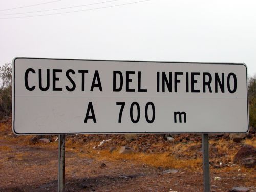
What has been an informal name for many years, has now been
institutionalized! Signs announcing the Santa Rosalia grade as
"Cuesta del Infierno" have appeared at both the bottom and top of the
great hill.
|

Click photo for
a larger image
|
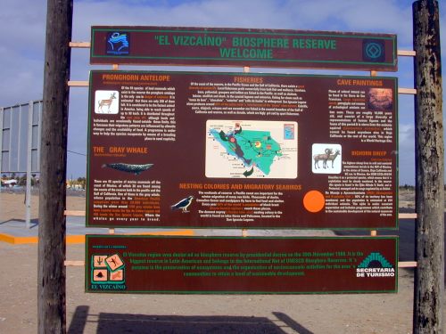
At the state line (28th parallel / Eagle Monument), a
sign announcing the Vizcaino Biosphere Reserve has been installed.
Some information about the species being protected in this
reserve is provided, as well as a map of the reserve.
|
November 2000
| |
|
|

Click photo for
a larger image
|
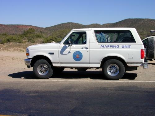
Many of us have used the AAA map of Baja California for years as
the most basic map source for traveling the major highways. Just
to show this mapping project is ongoing, here is a photo of the
AAA Mapping Unit stopped at Nuevo Rosarito (north of Villa Jesus
Maria).
|
October 2000
| |
|
|

Click photo for
a larger image
|
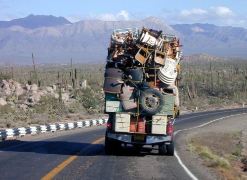
While the drive south in late October was uneventful, I did take
one photo worth showing. I'm behind someone from California
who's clearly moving south, and who seems to have forgotten the
kitchen sink!
|
May 2000
| |
|

|

|

|

|
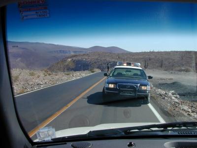
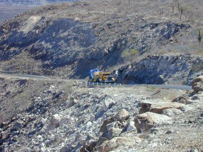
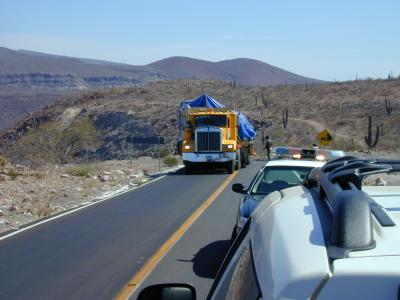
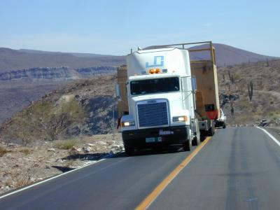
| Click photo for a larger image |
The only unusual event on my drive south in May 2000 occurred at the top of
the steep grade down to Santa Rosalia. As I approached the top
there was a Highway Patrol car facing me in my lane, with all
lights flashing. I pulled up to the patrol car and was informed
that a very wide machine was being brought up the hill. It would
be just a moment.
This sounded quite interesting, so I got my camera and waited
in the road. After about 30 minutes a pickup truck came up the hill
and parked. A man got out with a video camera slung around his
neck. Our mutual interest in photographing this event gave us a
basis for discussing what was about to happen. It turns out the
machine was a turbine generator going to the Las Virgenes
geothermal area, and would be coming up the hill in two pieces.
The unit had been delivered across the Gulf from Topolobampo (I
assume on a special ferry trip).
When the trucks with the turbine finally made it up the hill,
they were indeed wide! I've included several of the photos I
took.
|
November 1999
| |
|
|
 |
|
 |
 |
 |
|
Click photo for a larger image
|
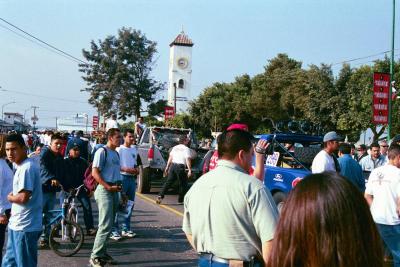
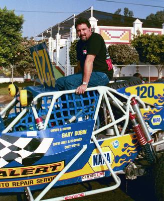
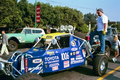
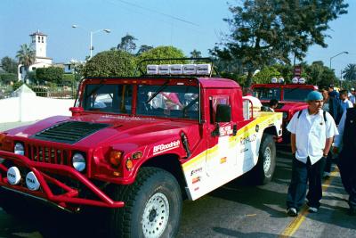
On my trip south I was passing through Ensenda thinking
mostly of breakfast. Suddenly I came upon a large crowd and a
large inflatable Tecate can. Well, breakfast came first, but
then I returned to the scene of the commotion and found
. . . check-in time for the Baja 1000 off-road race!
I've added a few photos I took wandering around the lineup of
vehicles. The first is interesting in that it shows the
multi-faceted nature of modern Ensenada - a cruise ship is
docked in the background, and race fans are milling about the
lineup. The second shows Gary Dubin posing with his car, and
the remaining two shots show some unidentified vehicles.
|
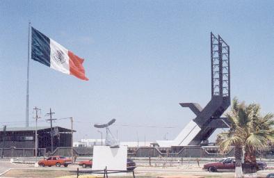
September 1997
| |
|
Sometimes in Southern California you see immense American flags
being flown, typically at automobile dealerships, especially
those selling foreign-made vehicles. Apparently, a
competition to see who can wave the largest flag. Well, in
Mexico, it seems that the Army is out to win the flag-waving
contest in that country.
As I was passing the Army base on the south side of Ensenada, I
noticed an unusually large Mexican flag flying. As I got
closer, I realized that this flag was, perhaps, the largest I'd
ever seen! It was standing out smartly in a fresh breeze off
the bay. Impressive!
The next day, as I neared the state border and the Eagle
Monument just north of Guerrero Negro, I again noticed something
flying in the distance. It appeared that two flags were flying
at the Army base newly-sited at the monument - probably one flag
flying from each of the Eagle's wings, I thought. When within a
mile or so, it became apparent that this was one flag -
I'd been seeing the green and red sections, while the white
section blended into the sky background.
This flag was also standing out smartly, in a more
than fresh breeze coming off the Pacific. A small dust storm had
sprung up around the Army encampment. Just as I reached the
circular road around the monument, the giant flag began to
lower. Concern over the safety of the flagpole, I'm sure.
I quickly began to wonder just how they'd get this giant piece
of cloth taken in. I stopped in the road outside the entrance to
watch. It took two soldiers to lower the flag, and ten
others to attempt taking it in!
I find it difficult to judge the size of these new Army-issue
Mexican flags. Perhaps 80 feet by 30 feet? At that size, we're
talking about 2400 square feet of "sail" to take in! And
probably a rather heavy weight of cloth to boot.

Note: In June '98 a new, heavy-duty flagpole was in place. The
flag again stood out in a fresh breeze, but there seemed to be
no concern for the flagpole. Here is a photo (click on the image
to bring up a larger version):