In a general sense, the Baja Peninsula divides in the middle into two weather zones. The northern half experiences weather similar to that of Southern California, while the southern half has weather patterns like those of Arizona. (To see this more dramatically, look at the color bars on the Rainfall and Temperature Chart.)
The northern half has its rainy season in the winter - storms come from the North Pacific and are generally moderate in strength when they reach Baja. The summer is usually dry and brings consistent winds along the Pacific coast.
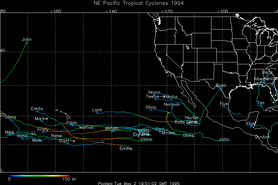
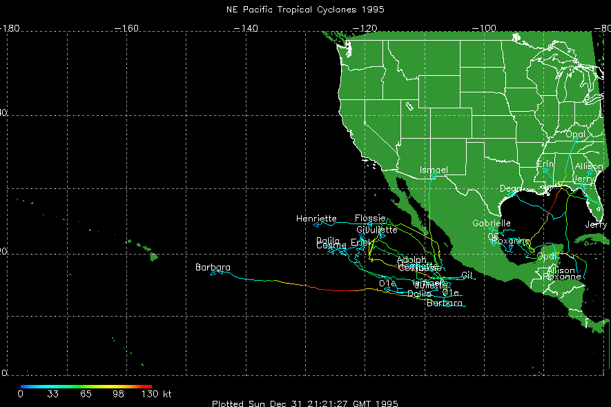
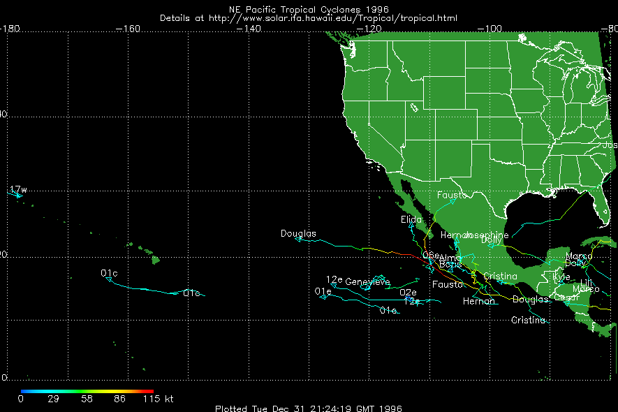
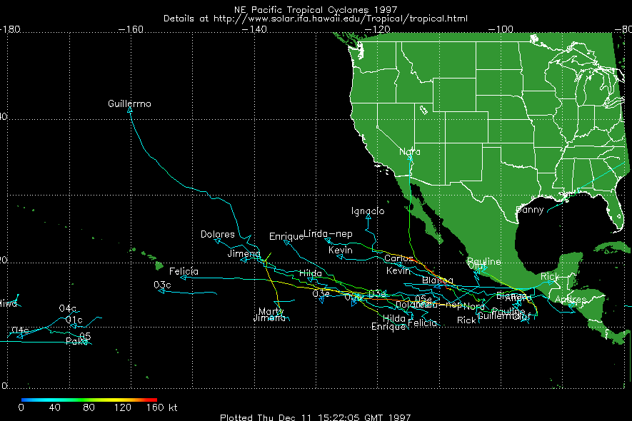
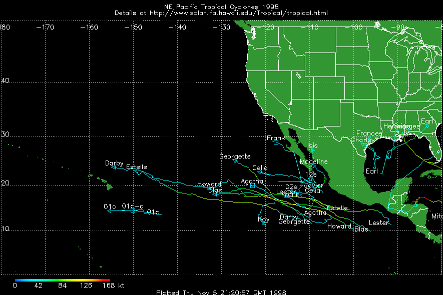
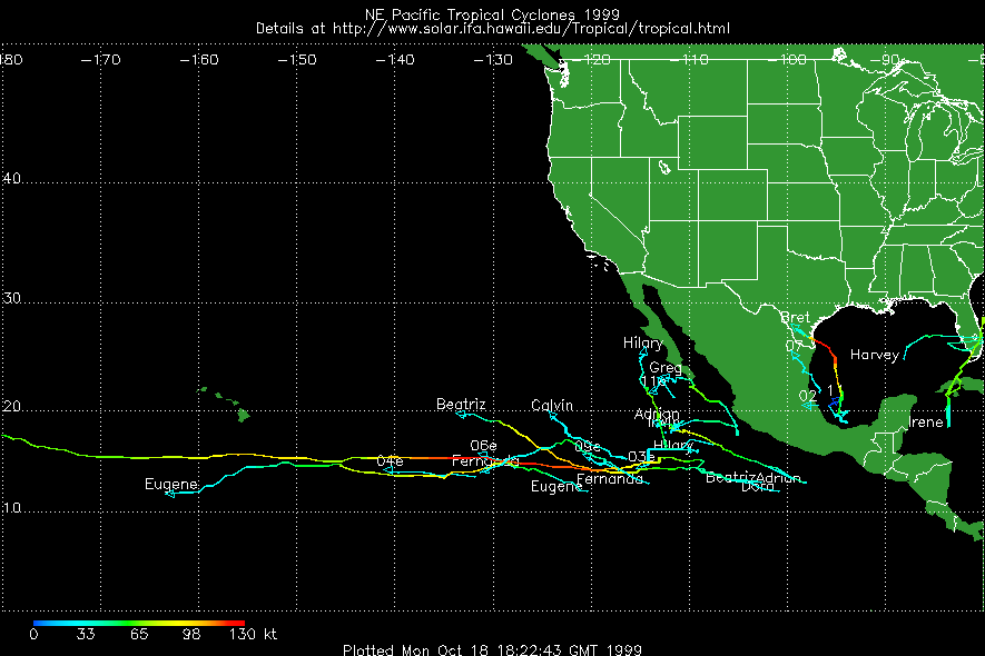
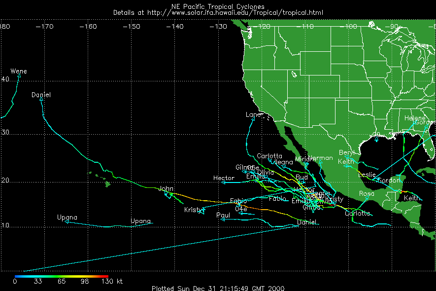
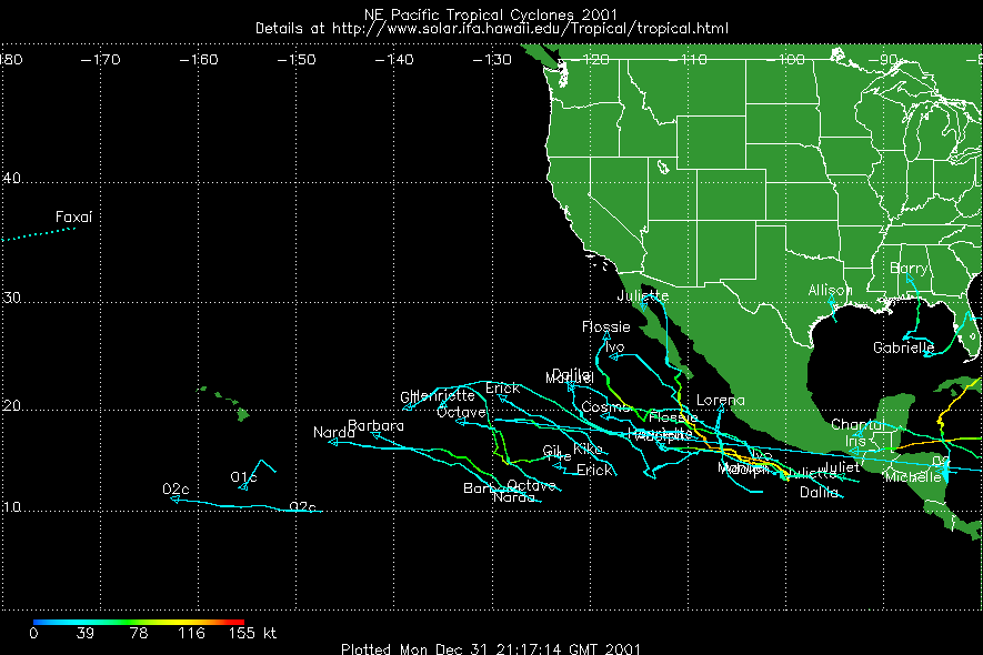
The southern half gets most of its rain during the "hurricane season" from July through October. There are exceptions to this, but as a general rule summer brings the rainy season. The storms come from all directions except the north. Hurricanes are spawned off Southern Mexico and tend to head northwest with a general pattern of moving out into the mid-Pacific - however, these hurricanes sometimes curve north, or north and then east, or north and then west, to pass over the southern areas of the Baja Peninsula. They can "hit" the peninsula from the south, west or east! (See the Historical Hurricane Plots below.)
The amounts of rainfall in the Southern areas vary tremendously from year to year. Some years will pass with essentially no rainfall at all. In others the rainfall amounts will rival those of (Alta) California, and the desert will become verdant and carpeted with wild flowers.
The heat of summer can be oppressive in some areas - while in other nearby areas breezes may keep much of this heat at bay. I personally enjoy the summers in Baja, especially the warm waters and very pleasant evenings.
One of the secrets to enjoying a summer stay in Baja California Sur is to plan your day around the temperatures. Activities should focus on morning or evening times. If you're going to the market, use the evening hours for this visit, just like the locals do. During the heat of mid-day keep your activities to a minimum, or make certain they occur in an air-conditioned environment.
If you are traveling in Baja California during the summer months, be sure to carry an emergency supply of water and a shade cover in case of a mechanical problem. Also make certain your vehicle is in good condition to start with, especially the cooling system. (You want to have the water available for human consumption, not for your car's cooling system!)
Basic rule for desert survival:
One gallon of water per person per day (This varies according to activities, but can be used as a "safe" guide.)
Basic comfort equation:
Summer + Satisfaction = Shade + Siesta (The equation of the four S's.)
Baja California is affected by several regular wind patterns. At certain times of the year these winds can strongly affect recreational activities. During the passage of hurricanes in the summer, and storms from the northwest in the winter, the regular wind patterns will be disrupted, and may be replaced by strong storm-generated winds.
Along the Pacific coast the prevailing wind is from the northwest, and funnels along the Baja Peninsula creating one of the more difficult upwind boat passages in North America. This wind is more regular during the summer, and follows the pattern found in Southern California. During the winter months this wind can blow more strongly during passing storms, but is irregular in its appearance.
Because most of Baja California has a spine of mountains running the length of the peninsula, this northwest wind is localized to the Pacific coastal region. The La Paz region, with a low plateau to the west, is the exception to this. Especially during the winter months when the northwest wind is blowing strongly, the La Paz region experiences a wind which drops the effective temperature and can raise heavy seas in the surrounding waters.
In the Sea of Cortez, the event of strong winds is usually associated with a high-pressure system in the southwestern U.S.. (This is the cause of the "Santa Ana wind" experienced in Southern California.) This high-pressure causes a strong flow of air to move from the higher desert regions (Nevada and Utah) to the lower regions in Southern Califonia. In particular, the air flows down through the Imperial Valleys of California and Mexico into the Sea of Cortez, where it is funneled for almost a thousand miles. This wind can blow for many days before relenting!
Local wind patterns exist in most areas. The most prominent of these is the Coromuel wind of La Paz. This wind is mainly a summer wind and is what makes La Paz one of the most favored places for summer residence in southern Baja California, at least on the Gulf side. The "Coromuel" usually springs up in the late afternoon and may blow all night. It is always from the south, and blows up through many of the islands to the north of La Paz. See the Infrequently Asked Questions Page (IAQ) for information on the origin of the term Coromuel wind.
While particulars of El Niño effects are difficult to predict, the general effects which might change the weather during a visit to Baja California appear to be well understood.
The basic rule seems to be that the warmer Pacific currents tend to produce warmer air and water temperatures, and more moisture. This rule translates into differing effects in the southern and northern halves of the peninsula, according to the general patterns discussed above.
As an example, during the 1997 hurricane season, there were a "normal" number of hurricanes, but one of these was a record-setter, and another was a real "killer".
Hurricane Linda was the strongest hurricane that has been recorded in NE Pacific waters - wind gusts peaked at over 200MPH! Hurricane Pauline was so "loaded with moisture" that extensive damage and loss of life occurred in Acapulco from flooding and mudslides.
It takes ocean waters of 82°(F) or more to sustain a hurricane. Since the warmer waters reached much further north, hurricanes tended to move to higher latitudes than normal. Hurricane Linda was predicted to head into Southern California at one point - with an expected land fall near Santa Barbara. So the exaggeration of effects brought on by El Niño can also move the general weather patterns of Baja California further north in the summer, and further south in the winter.
The water temperatures in the Sea of Cortez went as high as 90°(F), and many of the far-ranging fish migrated far to the north, especially on the Pacific side.
The effects of El Niño produced both bad results (Hurricane Pauline) and good results (rebuilt water tables and turned the peninsula into a garden). The same should be true in the more northern areas during the winter months, if El Niño produces major weather changes. Keep in mind the fact that, in the northern areas, the winter storms will not be of hurricane strength.
Here is a link to a current temperature image for the waters surrounding Baja California. If you become aware of other sites which also provide useful information, please forward the web addresses to me at: ftm@math.ucr.edu
NOAA - CoastWatch (GOES Satellite)
Before taking the El Niño effects too seriously, remember that:
one person's El Niño is another person's cute little grandchild!
(Thanks to Murdoch Hughes for this observation.)
Here is the list of names to be assigned to named tropical storms in the Eastern Pacific region during 2011:
ADRIAN MAX BEATRIZ NORMA CALVIN OTIS DORA PILAR EUGENE RAMON FERNANDA SELMA GREG TODD HILARY VERONICA IRWIN WILEY JOVA XINA KENNETH YORK LIDIA ZELDA
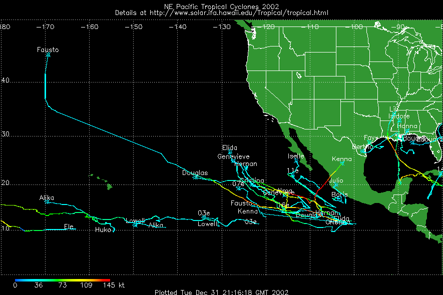
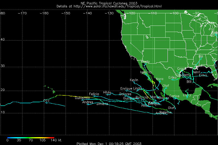
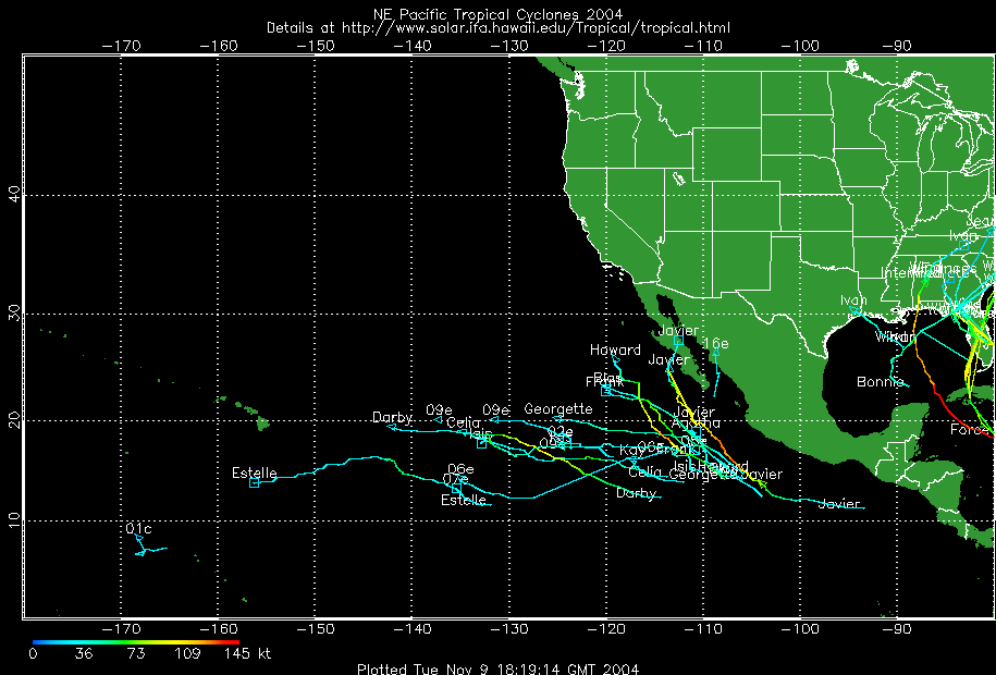
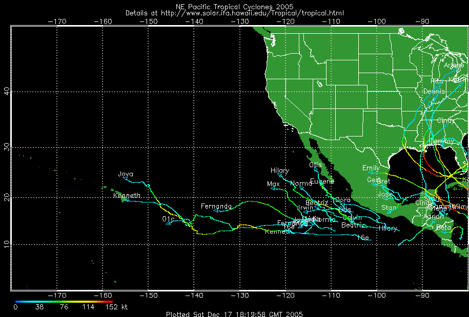
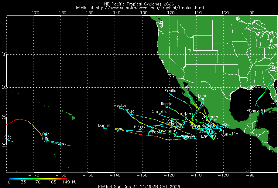
Here are some charts showing historical data on hurricane paths in recent years. Each chart is a local copy of a GIF image about 21K in size. The charts are provided from my son's Tropical Storm Tracking Site at
Display by replacing the current page (use the Back button to return):
http://www.solar.ifa.hawaii.edu/Tropical (Tom Metcalf) Display by opening a separate window (click on the image to close the window):
1994 1995 1996 1997 1998 1999 2000 2001 2002 2003 2004 2005 2006
(Requires JavaScript)
1994 1995 1996 1997 1998 1999 2000 2001 2002 2003 2004 2005 2006
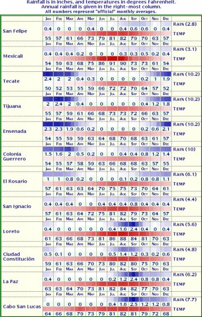
The chart of rainfall amounts and temperatures at selected locations is rather large, and is included on a separate page. There are two versions available - a "text" version which will be much quicker to download, but may be too much of a challenge for some browsers; and a "graphics" version which will not download so quickly, but can be displayed by most browsers.
Text Version
Rainfall-Temperature Chart
(78K text file)
For the "tables-capable" browserGraphics Version
Rainfall-Temperature Chart
(80K JPEG image)
For the "tables-challenged" browserTechnical Digression: The text version downloads much more quickly due to compression of text information as it is transmitted to your modem. The graphics version, although about the same size, is already compressed and does not benefit from file compression across the phone lines.
Once the file arrives at your browser, the situation reverses. The graphics image displays quickly, while the text version has a very extensive table (actually nested tables) which will take even a fast PC at least 15 seconds to set up.
Here are a collection of links to sources providing current weather forecasts for areas of Baja California. Some of these are repeated on the Related WWW Sites Page. Since I don't know the "real" source for the weather forecasts, listing them here does not imply any judgement on the quality of the forecast.
Yahoo! weather forecasts:
- Ensenada
- Guerrero Negro
- Mulege
- Loreto
- La Paz
- Los Cabos
- NOAA:
(1) Ocean Surface Temperatures from NOAA
(2) Ocean Surface Temperatures from NOAA
- US Naval Oceangraphic Office:
Wave Heights and Directions
- Weather Underground:
Ocean Temperatures from the Weather Underground
- Virtual Bouy Observations from bouyweather.com